Map Options
The Map Options Panel allows you to control the elements and information that is displayed on the map.
The map options panel is located in the top left hand corner of the map. Simply click the Map Options button to open or close the Map Options Panel.
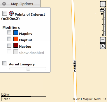
The Map Options Panel looks like this:
You can enable/disable the following map options:
Points of Interest: Displays your fleet's points of interest on the map. These do not include NAVTEQ POIs or fuel POIs. Points of interest can be viewed on the map at scale level 10 and higher.Fleet Modifiers (e.g.
Mapdev): Displays your fleet's modifiers on the map. Fleet modifiers can be viewed on the map at scale levels 6 and higher.Maptuit: Displays Maptuit global modifiers on the map. Maptuit's modifiers are drawn from our data sources, including feedback from drivers. Maptuit global modifiers can be viewed at map scale levels 11 and above.Navteq: Displays NAVTEQ modifiers on the map. Navteq modifiers can be viewed on the map at scale levels 11 and above.Show disabled: Displays disabled modifiers on the map. Disabled modifiers can be viewed on the map at scale levels 6 and above.Note: The
Show disabledoption is only accessible if you have selected at least one modifier source (e.g. your fleet, Maptuit, or Navteq). WhenShow disabledis selected, disabled modifiers are only displayed on the map for the selected source(s) (e.g. your fleet, Maptuit, or Navteq).Displays the map using aerial imagery. When this option is enabled, you can use the slide bar to control the degree of aerial imagery transparency. Aerial imagery can be displayed at all map scale levels but is only available for maps of the USA and some portions of Canada.
Note: To enhance map performance, some map options are only available at a minimum scale level. If you are zoomed out too far for a particular map option, the option is grayed out and no longer available. After you zoom in to a certain level, the option will become active again.
